This route contains breathtaking views and challenging hills, of course, but is also less remote and isolated than your typical Super Randonnée. As a result, there are certain highway and urban sections you’ll have to watch for traffic!
Here’s a blurb about the ride:
This ride begins by following the Sea to Sky Highway, a route with incredible views of the coastal mountains, and the same road used by the Whistler Gran Fondo (largest fondo in North America and 2020 UCI Gran Fondo world championship course). At Whistler, a steep climb provides a view of the valley. It then continues through alpine meadows and lakes to Joffre Lakes Provincial park up the famous climb of the Duffy Lake Road, a park that sees thousands of visitors each weekend during its busy season.
The return ride is no less spectacular, stopping at the Olympic Ski park and hiking destination, the Callaghan Valley, and returning via the coastal road of Marine Drive.
Next the route visits the World famous “North Shore” – renowned for mountain biking, but also home to some famous mountains with spectacular views of the Vancouver region. It ascends several grueling climbs, including mountains known as the “Triple Crown”, as well as following some steep and undulating, car-free roads through the lush evergreen forests of North Vancouver.
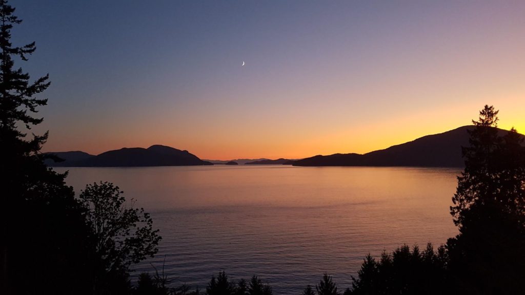
The ride culminates with a finish atop Prospect Point, in Stanley Park with views of the bridge and mountains.
Equipment Choice
To ride this route, a “regular road bike” is sufficient. There are a couple of sections of gravel on urban trails, but nothing I have not completed on 23mm tires and rim brakes before.
As it is in the Pacific-Northwest region, fenders/mudguards are highly recommended, as the weather can change or have spot-showers that start/end in very isolated areas.
You will not need copious amounts of water, as services are fairly regular (in the second part of the route, you can probably do each mountain ascent on one waterbottle and refill at the top/bottom).
The only long section without services is Pemberton -> Joffre and back.
Strategy
The ride is designed to be ridable in two distinct sections -> the Sea to Sky Highway + Return, and the mountain climbing segments.
I would not recommend riding through the night, not for danger reasons, but simply because you’ll miss some of the views. (Well, I suppose there could be deer on the mountain descents).
I would propose these possible strategies:
- Ride the Sea-to-Sky and back in your first day. Sleep in Vancouver.
Look in the West End of Vancouver, or Downtown Core for hotels.
Your second day is then the local mountains. - Ride the Sea-to-Sky on the first day, and stop for a sleep in Squamish. Your second day finishes the return journey and begins the mountain ascents once back in the urban roads.
- Ride the Sea-to-Sky on the first day, and push back into town and find accommodation at SFU on Burnaby Mountain. You can then do a second day which is just the north shore, and start your day on a mountain top ?
- Split the ride into 3 days. The first day to Joffre Lakes and back to Whistler. Day 2 is Callaghan valley, back to Vancouver, up Burnaby Mountain, and to the North Shore.
You can then sleep somewhere before/after a climb. Suggestions:
Capilano University, Mount Seymour Area, Grouse Mountain Area.
Doing the Seymour Demonstration Forest/Conservation Reserve section at night could be amazing (road closed to cars), but there is a high-likelihood of bear encounters ?
Further Notes
The route, as described in the route sheet, is Provence Randonneurs/ACP compliant. No roads are used in the same direction twice, and there are controls at the extreme points.
One place where this may be problematic is the crossing of the Lion’s Gate bridge. The route does recommend using the East/West sidewalks dependant on which leg of the route you are on.
If I were designing a route with no such constraints, I would suggest that when you cross northwards (heading to the North Shore), you take the east side of the bridge, and when you return you take the west side of the bridge. This is by far the safest way of doing so, and avoids riding against upstream pedestrian/rider traffic.
As a route organizer it is impossible to verify which side of the bridge you ride on. GPS is not that accurate. Distances are the same. ?
The section up to the Whistler Sliding centre may have a barrier on it. It is my experience that even if an employee meets you, they do not care if you are a bicyclist riding through. So simply carry on those roads. The whole road is a through-route to get to the Whistler Zipline centre, so if you are questioned and it does not sound positive (I have no idea why this would be), simply say you are heading to the Zipline.
If you do encounter a bear, it is most likely a black bear. They tend to be far less aggressive than their Grizzly counterparts. However, if there are cubs around, this may not be the case.
You have to be sensible, make noise if you are riding completely solo (no other riders/cars), and just turn around and wait if you do see a bear. A SR600 is not worth confronting a bear!
There are a plethora of bike shops along the route, some with road bike and some with mountain bike focus. Most are open 10AM-6PM and 12PM-5PM on Sundays.
Reports
Étienne’s Report from 2019 – https://www.randonneurs.bc.ca/newsletter/submissions_2019/052_sea-to-skies-SR600_etienne-hossack.html
The BC Randonneurs Database Page is here: https://database.randonneurs.bc.ca/route/790
The cue sheet allows you to plug in your estimated riding speed. Current values are set to Étienne’s initial ride in 2019.
The ride organizer is Étienne, who can be contacted here.
He is happy to recommend places to stay, shops to use, or anything further.